Carlson North Pier Pair


Local Name:

Carlson North Pier Pair

Depth:

Depth is about 10 feet.

Anchoring:

Anchor anywhere nearby. Just be careful as it gets very shallow in here!

Location:

Latitude Longitude
Degrees Minutes Seconds Degrees Minutes Seconds
8 44 55.680 167 41 16.200
8 44.92800 --------- 167 41.27000 ---------
8.74880 --------- --------- 167.68783 --------- ---------

Notes:

This pair was sunk pre-1974, but the date of their actual sinking is not known to me at this time. Anyone out there have any ideas?

I snorkeled these wrecks. There's not too much left to see except engines and some batteries.

Photos:

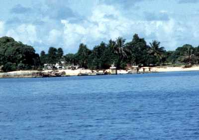
Here's a shot from 1974 showing these two LCM-type vessels sunk in shallow water right at the Carlson pier. Once again, we are lucky that Scott Johnson was here to capture these images!

Photo by Scott Johnson
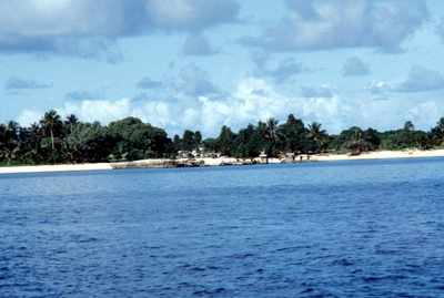
Just a slightly different angle of our wrecks.

Photo by Scott Johnson
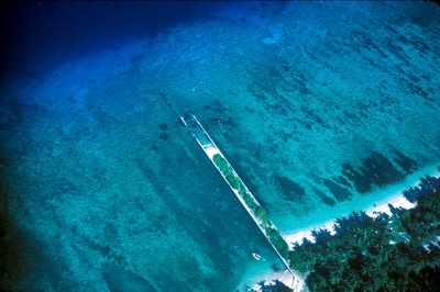
Now here is a more recent photo (2005/2006?) taken by Scott Johnson while flying over Carlson Island. You probably want to click on this image to view the larger version in order to see the details. You should be able to clearly see the outline of the two LCM-type wrecks to the north (left) of the pier. You will also note another LCM-type craft sunk on the southern side (right) of the pier. I have not had a chance to go back and mark this one, but rest assured, I will have that added soon!

Photo by Scott Johnson

Nearby Attractions:


From: Carlson North Pier Pair
AttractionDistance (feet)Bearing (deg mag)
Carlson South Pier Wreck 165 116
Parker/Long LCM 522 67


Go to Map Based Wreck Directory

Go to List Based Wreck Directory

Go to Wreck Page

Go to Scuba Diving Page

Go to Dave Fortin's Homepage

Send e-mail to Dave Fortin


This page has been accessed 12 times.

Created by Dave Fortin

Fri Apr 26 01:08:36 UTC 2024