Shell Island Wreck
Local Name:
Shell Island Wreck
Depth:
This wreck is maybe 70 feet to the deck and about 90 feet to the bottom.
Length and Orientation info:
The approximate length and approximate orientation of the ship are deteremined based on the lat and lon of the bow and stern. Typically, the lat/lon information was obtained by attaching a line with a float to the wreck and marking the position of the float with a handheld GPS receiver. We try to get the line as near vertical as possible, but there is bound to be some error. Also, the GPS position will have a certain error in it as well. So, this information will be reasonable, but not 100 percent accurate.
Stern Position:
Latitude : 8 deg 50.170 min 0 sec
Longitude: 167 deg 44.174 min 0 sec
Bow Position:
Latitude : 8 deg 50.186 min 0 sec
Longitude: 167 deg 44.184 min 0 sec
Approximate length: feet
Approximate orientation: deg mag
Anchoring:
This is one of the easier wrecks to find even w/o GPS. You want to anchor near the concrete pier near the north end of Shell Island. Just slighly south of the pier there is a sandy channel heading out away form the pier. Follow this straight out. The wreck should come into view within a minute or so after leaving the dropoff.
Location:
| Latitude |
Longitude |
| Degrees |
Minutes |
Seconds |
Degrees |
Minutes |
Seconds |
| 8 |
50 |
10.200 |
167 |
44 |
10.440 |
| 8 |
50.17000 |
--------- |
167 |
44.17400 |
--------- |
| 8.83616 |
--------- |
--------- |
167.73623 |
--------- |
--------- |
Notes:
This is a very popular wreck. It is easy to find and a nice easy swim. The wreck is similar to our Ski Area Wreck and is sitting upright on the bottom facing north. Severe damage can be seen on the starboard side of the stern which must have been the cause of the sinking.This area is known for manta rays, so generally after we spend sometime on this wreck we will head back towards the top of the dropoff (at 30-40 feet) and swim south for a little while looking for mantas.
Photos:
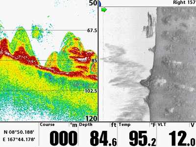
|
A beautiful side scan sonar image that gives a nice clear view of this wreck!
Image by Bob Swanson |
Go to Map Based Wreck Directory
Go to List Based Wreck Directory
Go to Wreck Page
Go to Scuba Diving Page
Go to Dave Fortin's Homepage
Send e-mail to Dave Fortin
This page has been accessed 12 times.
Created by Dave Fortin
Fri Jul 18 23:17:12 UTC 2025
