Eller Island Wreck #3


Local Name:

Eller Island Wreck #3

Depth:

This wreck is very shallow. Most of the debris is in less than 20 feet of water.

Anchoring:

This wreck is out of the B-boat (rental boat) area, so at the present time it is only accessible by private boat. You simply anchor near the wreck. However, I believe that the bottom drop off sharply into the lagoon so anchoring can be difficult. We went on a very calm day. If the wind is moderate and out of the east it may push your boat up on the reef, so be very careful. This wreck comes right to the surface, so you don't want to be right on top of it.

Location:

Latitude Longitude
Degrees Minutes Seconds Degrees Minutes Seconds
9 1 36.480 167 33 55.500
9 1.60800 --------- 167 33.92500 ---------
9.02680 --------- --------- 167.56541 --------- ---------

Notes:

Note on Name: I don't believe that there is any real convention on naming of the wrecks at Eller. Since there are three know wrecks on the lagoon side, I am just going to label them #1, #2, and #3 going from south to north.

Wrecks #2 and #3 are very close together and both very shallow. We anchored in between them and just swam between the two. Seems like a good plan.

Photos:

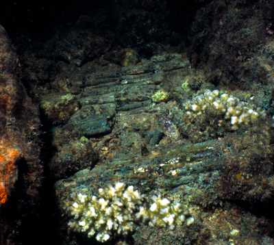
I appologize for the poor photo, but if you go there this might make a nice shot if exposed properly! What you are seeing are three rows of small arms ammo in a stack. I ASSUME that they must have been in a box of some sort that is now gone. The ammo is all green and fused in one big chunk.
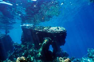
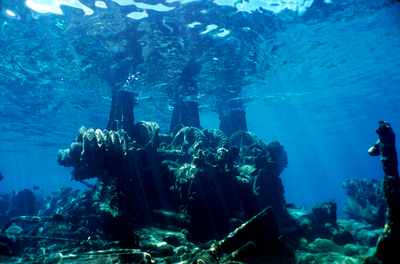
This is one of the most noticable features of this wreck and Eller Island Wreck #2; the boiler. Both boilers break the surface.
Just some of the junk there. Anyone have any idea that this might be?
This was a nice surprise! Since it was in less than 10 feet of water I would have expect that it might have been removed, but apparently not.
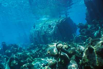
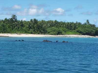
Here's what the wreck looks like from the surface. You are seeing the boiler and some of the other debris breaking the surface.
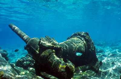
Another common sight between this wreck and Eller Island #2; the winch.

Nearby Attractions:


A few words of caution are due here!

While I believe that this data is fairly accurate, one must apply some common sense when using this data. If the point of origin is a coral head, you may have anchored at a slightly different spot than I did and your bearing to the next attraction could be slightly different than mine. I suggest checking with your own GPS before rolling in!

Also, know roughly how fast you swim so that you know approximately how long it should take to reach the next attraction. You can (and likely will) miss things from time-to-time and you should know when to abort and turn around before you are too far from your boat.

I strongly urge you to try the shorter swims first and build your navigation skills. I have set the cutoff distance for this table to 750 feet, but that is a considerable challenge even for the best navigators. An error of more than a few degrees in poor visibility and you can easily miss your destination at the extreme ranges!

From: Eller Island Wreck #3
AttractionDistance (feet)Bearing (deg mag)
Eller Island Wreck #2 548 151


Go to Map Page for This General Area

Go to Map Based Wreck Directory

Go to List Based Wreck Directory

Go to Wreck Page

Go to Scuba Diving Page

Go to Dave Fortin's Homepage

Send e-mail to Dave Fortin


This page has been accessed 653 times.

Created by Dave Fortin

Fri Sep 10 08:20:06 UTC 2010