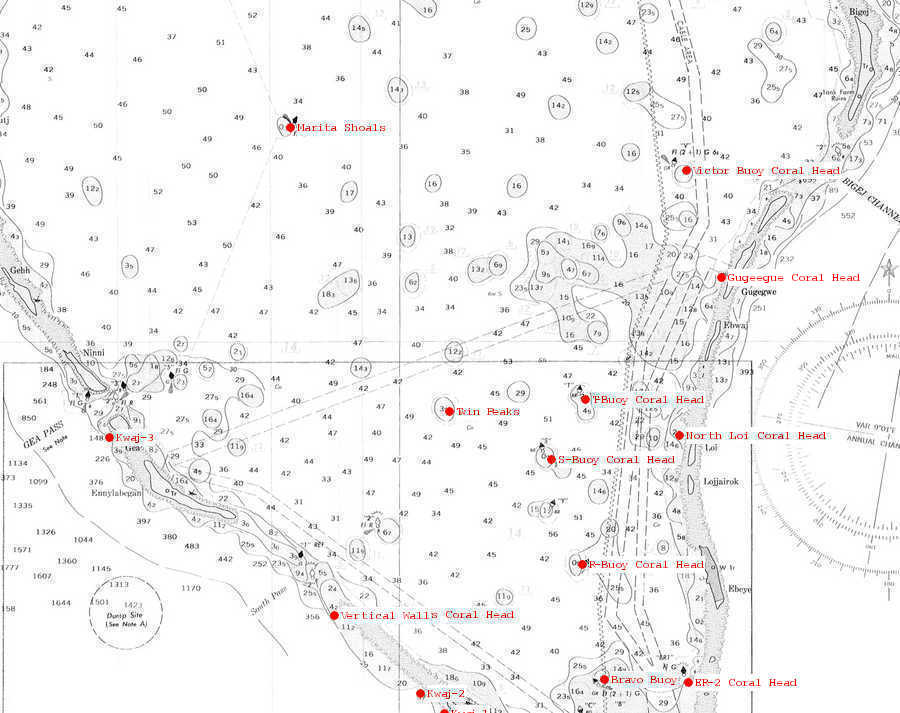
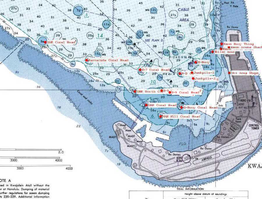
Dave Fortin's Kwajalein Dive Sites
Click on one of the site markers (red dots) on the map to see more details about the site.
|
|
|
Name:
Marita Shoals
Location:
| Latitude |
Longitude |
| Degrees |
Minutes |
Seconds |
Degrees |
Minutes |
Seconds |
| 8 |
52 |
53.580 |
167 |
38 |
31.620 |
| 8 |
52.89300 |
--------- |
167 |
38.52700 |
--------- |
| 8.88155 |
--------- |
--------- |
167.64211 |
--------- |
--------- |
Notes:
I have several times. Great spot! Several giant clams. This fallS within the range of the new extended B-Boat area!
Name:
K-9 Deep
Location:
| Latitude |
Longitude |
| Degrees |
Minutes |
Seconds |
Degrees |
Minutes |
Seconds |
| 8 |
43 |
57.900 |
167 |
43 |
33.720 |
| 8 |
43.96500 |
--------- |
167 |
43.56200 |
--------- |
| 8.73275 |
--------- |
--------- |
167.72603 |
--------- |
--------- |
Notes:
This coral head is not far from the larger K-9 coral head. It is smaller and a little deeper (about 20-25 feet) to the top which makes it slightly harder to see. There is some small arms ammo on the top of the coral head and numerous artillery shells can easily be found in the area around this coral head. This coral head is a great place to anchor when diving G-Buoy wreck. The wreck is only about 3 minutes away!
Nearby Attractions:
A few words of caution are due here!
While I believe that this data is fairly accurate, one must apply some common sense when using this data. If the point of origin is a coral head, you may have anchored at a slightly different spot than I did and your bearing to the next attraction could be slightly different than mine. I suggest checking with your own GPS before rolling in!
Also, know roughly how fast you swim so that you know approximately how long it should take to reach the next attraction. You can (and likely will) miss things from time-to-time and you should know when to abort and turn around before you are too far from your boat.
I strongly urge you to try the shorter swims first and build your navigation skills. I have set the cutoff distance for this table to 750 feet, but that is a considerable challenge even for the best navigators. An error of more than a few degrees in poor visibility and you can easily miss your destination at the extreme ranges!
Name:
K-9 West Coral Head
Location:
| Latitude |
Longitude |
| Degrees |
Minutes |
Seconds |
Degrees |
Minutes |
Seconds |
| 8 |
44 |
0 |
167 |
43 |
23.280 |
| 8 |
44.00000 |
--------- |
167 |
43.38800 |
--------- |
| 8.73333 |
--------- |
--------- |
167.72313 |
--------- |
--------- |
Notes:
This is a small coral head, but it is worth your while to check this one out. I'd suggest anchoring on K-9 Coral head and swimming over here. We easily did this in about a 4 or 5 minute swim.
Nearby Attractions:
A few words of caution are due here!
While I believe that this data is fairly accurate, one must apply some common sense when using this data. If the point of origin is a coral head, you may have anchored at a slightly different spot than I did and your bearing to the next attraction could be slightly different than mine. I suggest checking with your own GPS before rolling in!
Also, know roughly how fast you swim so that you know approximately how long it should take to reach the next attraction. You can (and likely will) miss things from time-to-time and you should know when to abort and turn around before you are too far from your boat.
I strongly urge you to try the shorter swims first and build your navigation skills. I have set the cutoff distance for this table to 750 feet, but that is a considerable challenge even for the best navigators. An error of more than a few degrees in poor visibility and you can easily miss your destination at the extreme ranges!
Name:
North Loi Coral Head
Location:
| Latitude |
Longitude |
| Degrees |
Minutes |
Seconds |
Degrees |
Minutes |
Seconds |
| 8 |
48 |
44.460 |
167 |
43 |
48.180 |
| 8 |
48.74100 |
--------- |
167 |
43.80300 |
--------- |
| 8.81235 |
--------- |
--------- |
167.73005 |
--------- |
--------- |
Notes:
This is a pleasant dive. This is a pretty good sized coral head just off the northern tip of North Loi island.
Name:
N-Buoy
Location:
| Latitude |
Longitude |
| Degrees |
Minutes |
Seconds |
Degrees |
Minutes |
Seconds |
| 8 |
44 |
18.840 |
167 |
43 |
45.840 |
| 8 |
44.31400 |
--------- |
167 |
43.76400 |
--------- |
| 8.73856 |
--------- |
--------- |
167.72940 |
--------- |
--------- |
Notes:
This little coral head is marked with a pole and a flashing green light and is located almost directly out from the ski platform in the ski area. The top can be a little smooth and tricky to anchor on, so make sure your boat is secure before leaving it! There's a nice anemone to the SW (roughly) right near the top of the coral head. To the east there is the "N-East" wreck and that general area to the east (there's another deeper coral head out there) is known for an abundance of coke bottles. Be careful diving off the east side of this coral head as there is a lot of boat traffic. These a small coral head to the south (roughly) that is only a minute or two away. That is a nice little side trip.
Nearby Attractions:
A few words of caution are due here!
While I believe that this data is fairly accurate, one must apply some common sense when using this data. If the point of origin is a coral head, you may have anchored at a slightly different spot than I did and your bearing to the next attraction could be slightly different than mine. I suggest checking with your own GPS before rolling in!
Also, know roughly how fast you swim so that you know approximately how long it should take to reach the next attraction. You can (and likely will) miss things from time-to-time and you should know when to abort and turn around before you are too far from your boat.
I strongly urge you to try the shorter swims first and build your navigation skills. I have set the cutoff distance for this table to 750 feet, but that is a considerable challenge even for the best navigators. An error of more than a few degrees in poor visibility and you can easily miss your destination at the extreme ranges!
Name:
R-Buoy Coral Head
Location:
| Latitude |
Longitude |
| Degrees |
Minutes |
Seconds |
Degrees |
Minutes |
Seconds |
| 8 |
47 |
.240 |
167 |
42 |
29.280 |
| 8 |
47.00400 |
--------- |
167 |
42.48800 |
--------- |
| 8.78340 |
--------- |
--------- |
167.70813 |
--------- |
--------- |
Notes:
This coral head is out a little ways in the lagoon from Ebeye. It is a nice little dive. Plenty to see.
Name:
S-Buoy Coral Head
Location:
| Latitude |
Longitude |
| Degrees |
Minutes |
Seconds |
Degrees |
Minutes |
Seconds |
| 8 |
48 |
25.500 |
167 |
42 |
3.900 |
| 8 |
48.42500 |
--------- |
167 |
42.06500 |
--------- |
| 8.80708 |
--------- |
--------- |
167.70108 |
--------- |
--------- |
Notes:
This is one coral head that I always enjoy. There is a pole marking it. It is roughly straight out form North Loi. I prefer this one in calmer weather.
Name:
T-Buoy Coral Head
Location:
| Latitude |
Longitude |
| Degrees |
Minutes |
Seconds |
Degrees |
Minutes |
Seconds |
| 8 |
49 |
13.740 |
167 |
42 |
31.920 |
| 8 |
49.22900 |
--------- |
167 |
42.53200 |
--------- |
| 8.82048 |
--------- |
--------- |
167.70886 |
--------- |
--------- |
Notes:
This is an excellent dive site! It's roughly between North Loi and Shell. Currently there is a green buoy nearby with a "5" on it. The buoy isn't directly on the coral head. The top of the coral head is a little deep (maybe 25 feet), but this is one coral head that is well worth your time! Plenty to see!
Name:
Troys Coral Head
Location:
| Latitude |
Longitude |
| Degrees |
Minutes |
Seconds |
Degrees |
Minutes |
Seconds |
| 8 |
46 |
20.100 |
167 |
40 |
2.580 |
| 8 |
46.33500 |
--------- |
167 |
40.04300 |
--------- |
| 8.77225 |
--------- |
--------- |
167.66738 |
--------- |
--------- |
Notes:
This is a very popular dive site here at Kwajalein. It is known for it's sharks. If sharks make you uneasy, this is not the place for you! Schools of fish swarm around the coral head and the sharks continually patrol through the school looking for a meal. There is a nice anemone on the southern side of the coral head near the top and some very nice coral on the nothern side, so try to be a little careful anchoring. If you dive it once you'll see the area that is beaten by the anchors. I think everyone tries their best to limit the damage and anchor here if they can.
Name:
Twin Peaks
Location:
| Latitude |
Longitude |
| Degrees |
Minutes |
Seconds |
Degrees |
Minutes |
Seconds |
| 8 |
49 |
3.600 |
167 |
40 |
41.460 |
| 8 |
49.06000 |
--------- |
167 |
40.69100 |
--------- |
| 8.81766 |
--------- |
--------- |
167.67818 |
--------- |
--------- |
Notes:
This is one of my favorite dives! This is one to save for the calm weather, but well worth your time! Anemones are everywhere! As the name implies, there are two coral heads here. You'll probably see the shallower one and anchor on it. You should find a concrete block on the top on the west side of the coral head. Going to the west (270) off the coral head (this should be more-or-less right being the concrete block) you can follow a little "saddle" to the coral head just to the west. Many more anemones there! If you like anemones, this is one of the best spots that I know of to find them!
Name:
Victor Buoy Coral Head
Location:
| Latitude |
Longitude |
| Degrees |
Minutes |
Seconds |
Degrees |
Minutes |
Seconds |
| 8 |
52 |
19.020 |
167 |
43 |
54.0 |
| 8 |
52.31700 |
--------- |
167 |
43.90000 |
--------- |
| 8.87195 |
--------- |
--------- |
167.73166 |
--------- |
--------- |
Notes:
This coral head is just inside Bigej Pass. These is a buoy (maybe a pole?) right next to it. This is always a nice dive. Being near the pass I have felt some fairly strong currents at times, so be alert if you are out there during a big tide swing.
Name:
MAR Fill Coral Head
Location:
| Latitude |
Longitude |
| Degrees |
Minutes |
Seconds |
Degrees |
Minutes |
Seconds |
| 8 |
43 |
42.840 |
167 |
43 |
22.500 |
| 8 |
43.71400 |
--------- |
167 |
43.37500 |
--------- |
| 8.72856 |
--------- |
--------- |
167.72291 |
--------- |
--------- |
Notes:
Another favorite coral head in the heart of the "Junk Area". LCMs, Anchors, bottles, ammo, etc litter this area. It seems that the bottles are more abundant to the East and harder to wind toward the island (S-W). Depth in this general area is about 50 feet, so it's a great place for open water divers to explore.
Nearby Attractions:
A few words of caution are due here!
While I believe that this data is fairly accurate, one must apply some common sense when using this data. If the point of origin is a coral head, you may have anchored at a slightly different spot than I did and your bearing to the next attraction could be slightly different than mine. I suggest checking with your own GPS before rolling in!
Also, know roughly how fast you swim so that you know approximately how long it should take to reach the next attraction. You can (and likely will) miss things from time-to-time and you should know when to abort and turn around before you are too far from your boat.
I strongly urge you to try the shorter swims first and build your navigation skills. I have set the cutoff distance for this table to 750 feet, but that is a considerable challenge even for the best navigators. An error of more than a few degrees in poor visibility and you can easily miss your destination at the extreme ranges!
Name:
Bravo Buoy
Location:
| Latitude |
Longitude |
| Degrees |
Minutes |
Seconds |
Degrees |
Minutes |
Seconds |
| 8 |
45 |
27.540 |
167 |
42 |
47.100 |
| 8 |
45.45900 |
--------- |
167 |
42.78500 |
--------- |
| 8.75765 |
--------- |
--------- |
167.71308 |
--------- |
--------- |
Notes:
This is an interesting coral head that is not too far from the marina. Thee isn't a whole lot of stuff on top for your anchors to grab onto, so be a little careful anchoring on this coral head. I'd suggest doing this on fairly calm days. There are 6 or 8 (I forget now) anemones on the west edge of the coral head, so please be careful that you keep your anchors away from that area.
Name:
Gugeegue Coral Head
Location:
| Latitude |
Longitude |
| Degrees |
Minutes |
Seconds |
Degrees |
Minutes |
Seconds |
| 8 |
50 |
52.080 |
167 |
44 |
22.320 |
| 8 |
50.86800 |
--------- |
167 |
44.37200 |
--------- |
| 8.84780 |
--------- |
--------- |
167.73953 |
--------- |
--------- |
Notes:
This coral head puts you very close to Taiyo Maru rubble wreck, but it is really almost just as easy to anchor up closer to the island and swim out to see the wreck and/or coral head. It is a very small coral head and getting a solid anchor on the windward side can be tricky. I really only list this in case you have noticed the coral head and have been tempted to anchor on it. Play it safe and just anchor near shore if you want to see this coral head.
Nearby Attractions:
A few words of caution are due here!
While I believe that this data is fairly accurate, one must apply some common sense when using this data. If the point of origin is a coral head, you may have anchored at a slightly different spot than I did and your bearing to the next attraction could be slightly different than mine. I suggest checking with your own GPS before rolling in!
Also, know roughly how fast you swim so that you know approximately how long it should take to reach the next attraction. You can (and likely will) miss things from time-to-time and you should know when to abort and turn around before you are too far from your boat.
I strongly urge you to try the shorter swims first and build your navigation skills. I have set the cutoff distance for this table to 750 feet, but that is a considerable challenge even for the best navigators. An error of more than a few degrees in poor visibility and you can easily miss your destination at the extreme ranges!
Name:
Ski Area Steps
Location:
| Latitude |
Longitude |
| Degrees |
Minutes |
Seconds |
Degrees |
Minutes |
Seconds |
| 8 |
44 |
11.640 |
167 |
44 |
8.220 |
| 8 |
44.19400 |
--------- |
167 |
44.13700 |
--------- |
| 8.73656 |
--------- |
--------- |
167.73561 |
--------- |
--------- |
Notes:
For local residents, you really don't need lat/lon to the ski area steps, but by adding them we can get some distance and bearing information to nearby attractions.
Nearby Attractions:
A few words of caution are due here!
While I believe that this data is fairly accurate, one must apply some common sense when using this data. If the point of origin is a coral head, you may have anchored at a slightly different spot than I did and your bearing to the next attraction could be slightly different than mine. I suggest checking with your own GPS before rolling in!
Also, know roughly how fast you swim so that you know approximately how long it should take to reach the next attraction. You can (and likely will) miss things from time-to-time and you should know when to abort and turn around before you are too far from your boat.
I strongly urge you to try the shorter swims first and build your navigation skills. I have set the cutoff distance for this table to 750 feet, but that is a considerable challenge even for the best navigators. An error of more than a few degrees in poor visibility and you can easily miss your destination at the extreme ranges!
Name:
Kwaj-1
Location:
| Latitude |
Longitude |
| Degrees |
Minutes |
Seconds |
Degrees |
Minutes |
Seconds |
| 8 |
45 |
.060 |
167 |
40 |
37.140 |
| 8 |
45.00100 |
--------- |
167 |
40.61900 |
--------- |
| 8.75001 |
--------- |
--------- |
167.67698 |
--------- |
--------- |
Notes:
This buoy was put in place by the environemntal folks here at Kwajalein in hopes to protect the reef from being damaged by anchors from the rental/private boats. I believe that the theory is to tie off on the tagline provided, but you should always drop a second anchor just to be safe!
Name:
Kwaj-2
Location:
| Latitude |
Longitude |
| Degrees |
Minutes |
Seconds |
Degrees |
Minutes |
Seconds |
| 8 |
45 |
16.020 |
167 |
40 |
17.820 |
| 8 |
45.26700 |
--------- |
167 |
40.29700 |
--------- |
| 8.75445 |
--------- |
--------- |
167.67161 |
--------- |
--------- |
Notes:
Similar to Kwaj-1.
Name:
Kwaj-3
Location:
| Latitude |
Longitude |
| Degrees |
Minutes |
Seconds |
Degrees |
Minutes |
Seconds |
| 8 |
48 |
42.780 |
167 |
36 |
4.440 |
| 8 |
48.71300 |
--------- |
167 |
36.07400 |
--------- |
| 8.81188 |
--------- |
--------- |
167.60123 |
--------- |
--------- |
Notes:
Similar to Kwaj-1 & Kwaj-2.
Name:
SAR Coral Head
Location:
| Latitude |
Longitude |
| Degrees |
Minutes |
Seconds |
Degrees |
Minutes |
Seconds |
| 8 |
44 |
32.160 |
167 |
42 |
6.060 |
| 8 |
44.53600 |
--------- |
167 |
42.10100 |
--------- |
| 8.74226 |
--------- |
--------- |
167.70168 |
--------- |
--------- |
Notes:
This small coral head is located not too far inside of SAR pass. I have not dove it yet. Any reports are welcome!
Name:
Barracuda Coral Head
Location:
| Latitude |
Longitude |
| Degrees |
Minutes |
Seconds |
Degrees |
Minutes |
Seconds |
| 8 |
44 |
20.160 |
167 |
42 |
33.420 |
| 8 |
44.33600 |
--------- |
167 |
42.55700 |
--------- |
| 8.73893 |
--------- |
--------- |
167.70928 |
--------- |
--------- |
Notes:
Just a small coral head located not too far behind Barracuda Junction. This is another one that that I haven't dove, so any reports are welcome!
Name:
Junkpile-1
Location:
| Latitude |
Longitude |
| Degrees |
Minutes |
Seconds |
Degrees |
Minutes |
Seconds |
| 8 |
44 |
12.000 |
167 |
43 |
43.320 |
| 8 |
44.20000 |
--------- |
167 |
43.72200 |
--------- |
| 8.73666 |
--------- |
--------- |
167.72870 |
--------- |
--------- |
Notes:
Hal Parker and I came across this based on information from Kent and Karen Degroff. We found it while exploring from "M-Buoy Coral Head" on scooters. We came across this fairly quickly, so you could probably anchor on N-buoy, swim to M-buoy and then head out. Another method is simply to anchor right on this site. Just be warned that it is deep. Depth here is about 100-110 feet. Be sure to have plenty of scope in the anchor lines if you anchor here!The area is loaded with all sorts of junk and it can be a fun place to explore! There are tires, batteries, bottles, plates, glasses, etc, etc.
Nearby Attractions:
A few words of caution are due here!
While I believe that this data is fairly accurate, one must apply some common sense when using this data. If the point of origin is a coral head, you may have anchored at a slightly different spot than I did and your bearing to the next attraction could be slightly different than mine. I suggest checking with your own GPS before rolling in!
Also, know roughly how fast you swim so that you know approximately how long it should take to reach the next attraction. You can (and likely will) miss things from time-to-time and you should know when to abort and turn around before you are too far from your boat.
I strongly urge you to try the shorter swims first and build your navigation skills. I have set the cutoff distance for this table to 750 feet, but that is a considerable challenge even for the best navigators. An error of more than a few degrees in poor visibility and you can easily miss your destination at the extreme ranges!
Name:
Junkpile-2
Location:
| Latitude |
Longitude |
| Degrees |
Minutes |
Seconds |
Degrees |
Minutes |
Seconds |
| 8 |
44 |
8.100 |
167 |
43 |
44.100 |
| 8 |
44.13500 |
--------- |
167 |
43.73500 |
--------- |
| 8.73558 |
--------- |
--------- |
167.72891 |
--------- |
--------- |
Notes:
Another large area with all sorts of junk! It appears to be all US junk that I suspect was just dumped years ago! Maybe tires, 55 gal drums, bottles, propellers (I've seen two), etc, etc.Depth is about 100-110 feet here. I don't know of a good place that is nearby to anchor, so you'd have to anchor deep. Make sure your anchor lines have plenty of scope if you try this!
I have listed Junkpile-3 separtely, but it is fairly close. These junk fields may in fact be all part of the same junkpile.
Nearby Attractions:
A few words of caution are due here!
While I believe that this data is fairly accurate, one must apply some common sense when using this data. If the point of origin is a coral head, you may have anchored at a slightly different spot than I did and your bearing to the next attraction could be slightly different than mine. I suggest checking with your own GPS before rolling in!
Also, know roughly how fast you swim so that you know approximately how long it should take to reach the next attraction. You can (and likely will) miss things from time-to-time and you should know when to abort and turn around before you are too far from your boat.
I strongly urge you to try the shorter swims first and build your navigation skills. I have set the cutoff distance for this table to 750 feet, but that is a considerable challenge even for the best navigators. An error of more than a few degrees in poor visibility and you can easily miss your destination at the extreme ranges!
Name:
Junkpile-3
Location:
| Latitude |
Longitude |
| Degrees |
Minutes |
Seconds |
Degrees |
Minutes |
Seconds |
| 8 |
44 |
7.560 |
167 |
43 |
46.080 |
| 8 |
44.12600 |
--------- |
167 |
43.76800 |
--------- |
| 8.73543 |
--------- |
--------- |
167.72946 |
--------- |
--------- |
Notes:
Another pile of junk that appears to be US and dumped here many years ago. I've seen bottles, sinks, tires, a toilet and all sorts of other junk. Depth here is about 100 feet. There's not really a good shallow place to anchor nearby, so you probably need to anchor deep. Be sure to use plenty of scope on the anchor lines if you do!
This is fairly close to Junkpile-2. While I believe that they are two separate piles of trash, they could actually run together.
Nearby Attractions:
A few words of caution are due here!
While I believe that this data is fairly accurate, one must apply some common sense when using this data. If the point of origin is a coral head, you may have anchored at a slightly different spot than I did and your bearing to the next attraction could be slightly different than mine. I suggest checking with your own GPS before rolling in!
Also, know roughly how fast you swim so that you know approximately how long it should take to reach the next attraction. You can (and likely will) miss things from time-to-time and you should know when to abort and turn around before you are too far from your boat.
I strongly urge you to try the shorter swims first and build your navigation skills. I have set the cutoff distance for this table to 750 feet, but that is a considerable challenge even for the best navigators. An error of more than a few degrees in poor visibility and you can easily miss your destination at the extreme ranges!
Name:
ER-2 Coral Head
Location:
| Latitude |
Longitude |
| Degrees |
Minutes |
Seconds |
Degrees |
Minutes |
Seconds |
| 8 |
45 |
25.20 |
167 |
43 |
55.800 |
| 8 |
45.42000 |
--------- |
167 |
43.93000 |
--------- |
| 8.75700 |
--------- |
--------- |
167.73216 |
--------- |
--------- |
Notes:
I know the buoy near this coral head has changed it's name, but I think the coral head will continue to be called ER-2 for those of us that have been on Kwajalein for a while. This coral head is between Little Bustard and Big Bustard. Right near the top (maybe 30 feet) on the southern edge of the coral head there is a little "shark nursery". You'll find a little area with small caves where the sharks hang out. Once you find this little nursery, it is usually pretty easy to find the sharks if you are patient and watch near one of the many openings.
Nearby Attractions:
A few words of caution are due here!
While I believe that this data is fairly accurate, one must apply some common sense when using this data. If the point of origin is a coral head, you may have anchored at a slightly different spot than I did and your bearing to the next attraction could be slightly different than mine. I suggest checking with your own GPS before rolling in!
Also, know roughly how fast you swim so that you know approximately how long it should take to reach the next attraction. You can (and likely will) miss things from time-to-time and you should know when to abort and turn around before you are too far from your boat.
I strongly urge you to try the shorter swims first and build your navigation skills. I have set the cutoff distance for this table to 750 feet, but that is a considerable challenge even for the best navigators. An error of more than a few degrees in poor visibility and you can easily miss your destination at the extreme ranges!
| From: ER-2 Coral Head |
|---|
| Attraction | Distance (feet) | Bearing (deg mag) |
|---|
| Little Bustard LCC | 739 | 176 |
Name:
Emon Coral Head
Location:
| Latitude |
Longitude |
| Degrees |
Minutes |
Seconds |
Degrees |
Minutes |
Seconds |
| 8 |
44 |
27.60 |
167 |
44 |
2.7720 |
| 8 |
44.46000 |
--------- |
167 |
44.04620 |
--------- |
| 8.74100 |
--------- |
--------- |
167.73410 |
--------- |
--------- |
Notes:
This little coral head/mound is just out beyond the roped area at Emon right that the drop from 15 feet to 30 feet. It is roughly in line with the E-W rope of the roped area that is roughly in front of what is now the Kayak Shack. For years there was always a float right next to this coral head. Now (May 2006) there are three floats out in that general area. iThis particaular little "coral head" is not far from the southern most buoy at htis time. This coral head is a great landmark for heading out to the toilet bowl and points beyond!
Nearby Attractions:
A few words of caution are due here!
While I believe that this data is fairly accurate, one must apply some common sense when using this data. If the point of origin is a coral head, you may have anchored at a slightly different spot than I did and your bearing to the next attraction could be slightly different than mine. I suggest checking with your own GPS before rolling in!
Also, know roughly how fast you swim so that you know approximately how long it should take to reach the next attraction. You can (and likely will) miss things from time-to-time and you should know when to abort and turn around before you are too far from your boat.
I strongly urge you to try the shorter swims first and build your navigation skills. I have set the cutoff distance for this table to 750 feet, but that is a considerable challenge even for the best navigators. An error of more than a few degrees in poor visibility and you can easily miss your destination at the extreme ranges!
Name:
Emon Scuba Shack
Location:
| Latitude |
Longitude |
| Degrees |
Minutes |
Seconds |
Degrees |
Minutes |
Seconds |
| 8 |
44 |
28.80 |
167 |
44 |
7.980 |
| 8 |
44.48000 |
--------- |
167 |
44.13300 |
--------- |
| 8.74133 |
--------- |
--------- |
167.73555 |
--------- |
--------- |
Notes:
While technically not a dive site, I have provided this to use as a landmark for finding hte "Emon Buoy Thing" and "Emon Coral Head". While snorkeling out you can check the bearing from the scuba shack to see if you are in the right area.
Nearby Attractions:
A few words of caution are due here!
While I believe that this data is fairly accurate, one must apply some common sense when using this data. If the point of origin is a coral head, you may have anchored at a slightly different spot than I did and your bearing to the next attraction could be slightly different than mine. I suggest checking with your own GPS before rolling in!
Also, know roughly how fast you swim so that you know approximately how long it should take to reach the next attraction. You can (and likely will) miss things from time-to-time and you should know when to abort and turn around before you are too far from your boat.
I strongly urge you to try the shorter swims first and build your navigation skills. I have set the cutoff distance for this table to 750 feet, but that is a considerable challenge even for the best navigators. An error of more than a few degrees in poor visibility and you can easily miss your destination at the extreme ranges!
Name:
Emon Buoy Thing
Location:
| Latitude |
Longitude |
| Degrees |
Minutes |
Seconds |
Degrees |
Minutes |
Seconds |
| 8 |
44 |
30.8820 |
167 |
44 |
3.2040 |
| 8 |
44.51470 |
--------- |
167 |
44.05340 |
--------- |
| 8.74191 |
--------- |
--------- |
167.73422 |
--------- |
--------- |
Notes:
Okay, so I'm not too great with names, but what else do you call this? This debris is right at the top of the slope off of Emon at about 15 feet. I use this as my landmark for heading out to the Concrete Wreck.
Nearby Attractions:
A few words of caution are due here!
While I believe that this data is fairly accurate, one must apply some common sense when using this data. If the point of origin is a coral head, you may have anchored at a slightly different spot than I did and your bearing to the next attraction could be slightly different than mine. I suggest checking with your own GPS before rolling in!
Also, know roughly how fast you swim so that you know approximately how long it should take to reach the next attraction. You can (and likely will) miss things from time-to-time and you should know when to abort and turn around before you are too far from your boat.
I strongly urge you to try the shorter swims first and build your navigation skills. I have set the cutoff distance for this table to 750 feet, but that is a considerable challenge even for the best navigators. An error of more than a few degrees in poor visibility and you can easily miss your destination at the extreme ranges!
Name:
Vertical Wall
Location:
| Latitude |
Longitude |
| Degrees |
Minutes |
Seconds |
Degrees |
Minutes |
Seconds |
| 8 |
46 |
19.140 |
167 |
39 |
7.800 |
| 8 |
46.31900 |
--------- |
167 |
39.13000 |
--------- |
| 8.77198 |
--------- |
--------- |
167.65216 |
--------- |
--------- |
Notes:
This waypoint is slightly north of a nice vertical wall. Be careful as the vertical section drops well below 130 feet, but there is plenty to see at at 130 and shallower. We typically anchor somewhere near the waypoint and swim south along the wall until we see the vertical section. There's actially two little vertical sections with a small gap between them. You'll know the second section for sure by the sharp 90 turn that the wall makes. Right in this corner is all sorts of nice coral to see. Now as we pass the wall and are heading south we like to head shallow and look for the next surge channel. If you follow that up, it will turn to the right a bit. Look right in the corner (north side) of that corner and, if you are in the right place, you'll find a nice little swim through into the next surge channel. As you go from one surge channel to the other there are a few anemones if you know where to look. Hopefully one of these days I'll add some sketches to try to point some things out!
Name:
Toilet Bowl
Location:
| Latitude |
Longitude |
| Degrees |
Minutes |
Seconds |
Degrees |
Minutes |
Seconds |
| 8 |
44 |
25.860 |
167 |
43 |
57.120 |
| 8 |
44.43100 |
--------- |
167 |
43.95200 |
--------- |
| 8.74051 |
--------- |
--------- |
167.73253 |
--------- |
--------- |
Notes:
This site is indeed a toilet bowl tht is siting on top of a large concrete block. There are several of these large blocks between here and just north of N-Buoy coral head.The toilet bowl itself was just set on top of the block. The depth to the toilet is right around 75 feet.
Nearby Attractions:
A few words of caution are due here!
While I believe that this data is fairly accurate, one must apply some common sense when using this data. If the point of origin is a coral head, you may have anchored at a slightly different spot than I did and your bearing to the next attraction could be slightly different than mine. I suggest checking with your own GPS before rolling in!
Also, know roughly how fast you swim so that you know approximately how long it should take to reach the next attraction. You can (and likely will) miss things from time-to-time and you should know when to abort and turn around before you are too far from your boat.
I strongly urge you to try the shorter swims first and build your navigation skills. I have set the cutoff distance for this table to 750 feet, but that is a considerable challenge even for the best navigators. An error of more than a few degrees in poor visibility and you can easily miss your destination at the extreme ranges!
Name:
GBR Coral Head
Location:
| Latitude |
Longitude |
| Degrees |
Minutes |
Seconds |
Degrees |
Minutes |
Seconds |
| 8 |
43 |
50.280 |
167 |
43 |
13.140 |
| 8 |
43.83800 |
--------- |
167 |
43.21900 |
--------- |
| 8.73063 |
--------- |
--------- |
167.72031 |
--------- |
--------- |
Notes:
Okay, someone needs to start a naming convention for some of these coral heads, so I'll call this one "GBR Coral Head" since it is directly out from GBR. This area is a lot of fun! There are at least 9 little wrecks that I can think of that are within easy swimming distance from this coral head. There's probably more if you are a little adventurous and search in this area! It is generally a little murky in this area. To the east I noticed a fair abundance of bottles. It was on this coral head that I found a Saki bottle, so this can be a great spot for a bottle collector!
Nearby Attractions:
A few words of caution are due here!
While I believe that this data is fairly accurate, one must apply some common sense when using this data. If the point of origin is a coral head, you may have anchored at a slightly different spot than I did and your bearing to the next attraction could be slightly different than mine. I suggest checking with your own GPS before rolling in!
Also, know roughly how fast you swim so that you know approximately how long it should take to reach the next attraction. You can (and likely will) miss things from time-to-time and you should know when to abort and turn around before you are too far from your boat.
I strongly urge you to try the shorter swims first and build your navigation skills. I have set the cutoff distance for this table to 750 feet, but that is a considerable challenge even for the best navigators. An error of more than a few degrees in poor visibility and you can easily miss your destination at the extreme ranges!
Name:
GBR North Coral Head
Location:
| Latitude |
Longitude |
| Degrees |
Minutes |
Seconds |
Degrees |
Minutes |
Seconds |
| 8 |
43 |
59.40 |
167 |
43 |
5.520 |
| 8 |
43.99000 |
--------- |
167 |
43.09200 |
--------- |
| 8.73316 |
--------- |
--------- |
167.71820 |
--------- |
--------- |
Notes:
I have just started poking around over here. It seems like a nice little area to explore.
Nearby Attractions:
A few words of caution are due here!
While I believe that this data is fairly accurate, one must apply some common sense when using this data. If the point of origin is a coral head, you may have anchored at a slightly different spot than I did and your bearing to the next attraction could be slightly different than mine. I suggest checking with your own GPS before rolling in!
Also, know roughly how fast you swim so that you know approximately how long it should take to reach the next attraction. You can (and likely will) miss things from time-to-time and you should know when to abort and turn around before you are too far from your boat.
I strongly urge you to try the shorter swims first and build your navigation skills. I have set the cutoff distance for this table to 750 feet, but that is a considerable challenge even for the best navigators. An error of more than a few degrees in poor visibility and you can easily miss your destination at the extreme ranges!
Name:
G-Buoy Coral Head
Location:
| Latitude |
Longitude |
| Degrees |
Minutes |
Seconds |
Degrees |
Minutes |
Seconds |
| 8 |
43 |
48.720 |
167 |
43 |
36.360 |
| 8 |
43.81200 |
--------- |
167 |
43.60600 |
--------- |
| 8.73020 |
--------- |
--------- |
167.72676 |
--------- |
--------- |
Notes:
This coral head is right outside the harbor. This is one that I haven't dove a lot, so I can't provide too much info on this. There is a nice field of "planted" artillery shells at bearing 315 (mag) about 3 minutes from the coral head. I'm note sure if they are live shells or not, but I'd treat ALL ammo in the lagoon as live!
Name:
K-10 Coral Head
Location:
| Latitude |
Longitude |
| Degrees |
Minutes |
Seconds |
Degrees |
Minutes |
Seconds |
| 8 |
44 |
11.400 |
167 |
43 |
35.280 |
| 8 |
44.19000 |
--------- |
167 |
43.58800 |
--------- |
| 8.73650 |
--------- |
--------- |
167.72646 |
--------- |
--------- |
Notes:
I just recently marked this. I haven't dove on it yet, so a report will have to wait until I can get out there.
Name:
K-7 Coral Head
Location:
| Latitude |
Longitude |
| Degrees |
Minutes |
Seconds |
Degrees |
Minutes |
Seconds |
| 8 |
44 |
13.860 |
167 |
43 |
9.00 |
| 8 |
44.23100 |
--------- |
167 |
43.15000 |
--------- |
| 8.73718 |
--------- |
--------- |
167.71916 |
--------- |
--------- |
Notes:
I have dove this a couple times. It is a fair sized coral head and, if I remember correctly, there are a couple nice anemones to see. Nice area. Hard to miss the coral head as it is fair sized and pretty close to the surface.
Name:
K-9 Coral Head
Location:
| Latitude |
Longitude |
| Degrees |
Minutes |
Seconds |
Degrees |
Minutes |
Seconds |
| 8 |
43 |
58.800 |
167 |
43 |
28.80 |
| 8 |
43.98000 |
--------- |
167 |
43.48000 |
--------- |
| 8.73300 |
--------- |
--------- |
167.72466 |
--------- |
--------- |
Notes:
This is a big coral head that is easy to find. I'm afraid that I don't have too many dives here, so I don't have much to say about it. It does work as a good place to anchor if you want to run over to K-9 West for a little bit and then come back and spend your remaining dive on this larger coral head.
Nearby Attractions:
A few words of caution are due here!
While I believe that this data is fairly accurate, one must apply some common sense when using this data. If the point of origin is a coral head, you may have anchored at a slightly different spot than I did and your bearing to the next attraction could be slightly different than mine. I suggest checking with your own GPS before rolling in!
Also, know roughly how fast you swim so that you know approximately how long it should take to reach the next attraction. You can (and likely will) miss things from time-to-time and you should know when to abort and turn around before you are too far from your boat.
I strongly urge you to try the shorter swims first and build your navigation skills. I have set the cutoff distance for this table to 750 feet, but that is a considerable challenge even for the best navigators. An error of more than a few degrees in poor visibility and you can easily miss your destination at the extreme ranges!
Go to Scuba Diving Page
Go to Dave Fortin's Homepage
Send e-mail to Dave Fortin
This page has been accessed  times.
Created by Dave Fortin
Fri Jan 11 06:08:11 UTC 2008